
Copyright © 2026 Apolitical Group Limited
Search across all content
Contact
 project
Filters empty triggers and protects privacy, freeing volunteers to tag wildlife.
As urban expansion and infrastructure development continue to accelerate within the City of Edmonton, local natural habitats are shrinking, and animal movement patterns are rapidly shifting. To track these vital environmental changes and reinforce climate resilience, the City of Edmonton partnered with the University of Alberta to launch WildEdmonton. Since 2018, this initiative has deployed a network of over 109 remote imaging cameras across city parks, river valleys, and green spaces to document local wildlife.
However, the immense scale of data collection quickly triggered a severe logistical and ethical bottleneck. The network captures over 100,000 new images each quarter, swelling the historical dataset to more than 1.3 million images. Managing this inventory became a physically impossible task for the project team, who faced a massive backlog driven by "false triggers”: empty images caused by environmental factors like shifting vegetation or weather events. Compounding this operational strain were strict municipal privacy regulations. Because these public cameras frequently capture passing residents, privacy rules mandated that any image containing a person be completely scrubbed or pixelated before researchers, volunteers, or the public could access the data. Sifting through millions of photos manually to filter out false triggers and safeguard human privacy would have been a gruelling, financially prohibitive endeavour for municipal staff.
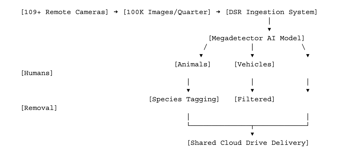
To eliminate this bottleneck, the City of Edmonton’s Data Science and Research (DSR) team developed an automated, end-to-end image-processing infrastructure. The architecture operates through a clear division of data ingestion, algorithmic classification, and open cloud distribution.
Part 1: Automated Data Collection & Ingestion Pipeline The monitoring network relies on fieldwork execution, where camera equipment is strategically rotated and maintained quarterly across urban wildlife corridors. The resulting influx of 100,000 quarterly images is aggregated and funnelled into a central ingestion system handled by the DSR team.
Part 2: Computer Vision Classification & Privacy Redaction Engine Instead of relying on costly proprietary software, the team integrated Microsoft’s open-source CameraTraps Megadetector model. The DSR team customised and engineered a full software system around this foundational model, training it to autonomously detect and classify three core entities: humans, animals, and vehicles.
Part 3: Automated Extraction & Secure Cloud Delivery Once an image is processed, the system automatically filters out empty environmental false triggers. For images flagged as containing humans, the engine removes them from the main image pool. The remaining high-quality images are then automatically exported to a shared cloud drive. This creates a completely optimised data pipeline that allows University of Alberta volunteers and ecological researchers to bypass manual sorting entirely and focus 100% of their energy on tagging animal species.
The deployment of the AI model shifted the WildEdmonton project from a stalled data backlog into an actionable urban planning asset. Key quantitative and qualitative outcomes include:
1. Drastic Operational Acceleration
The AI model analysed a staggering 800,000 images in a window of just two to three weeks—an analytical milestone that would have consumed hundreds of hours if performed manually.
2. Volunteer Efficiency Gain
By eliminating the burden of filtering empty frames and human interactions, the automated pipeline reduced volunteer species-tagging time by 62%.
3. Zero-Budget Technical Maturity
Developed entirely in-house by an internal team of eight using open-source tools, the solution required zero additional municipal budget allocation.
4. Tangible Urban Design & Safety Outcomes
By unlocking the dataset, city planners successfully identified narrow or fragmented ecological corridors. This intelligence directly informed the design of wildlife passages: corridors structured to allow safe animal migration through the city while minimising vehicular collisions and dangerous human-wildlife traffic interactions.
5. Expanded Ecological Discoveries
Seamless data processing empowered researchers to identify 28 unique mammal species and 45 bird species. This led to the discovery of two species entirely new to Edmonton's tracked boundaries (Elk and Raccoon), while verifying that invasive species like Wild Boar have not yet entered the municipality.
6. Civic Engagement & Public Trust
By utilising automated privacy redaction, Edmonton successfully balanced open-data transparency with individual privacy. The city can safely open-source wildlife imagery to neighbouring municipalities, partners, and the general public, empowering residents to become active environmental stewards.
Launch year: 2020
Privacy rights and legislation





Connect with 500,000+ public servants solving your hardest challenges.
Connect with 500,000+ public servants solving your hardest challenges.
Help public servants worldwide learn from your work, what worked, what flopped and what you'd do differently


Log in or sign up to continue the conversation